Scientists have unearthed evidence of a vast, ancient landscape hidden beneath the ice of Antarctica’s Gamburtsev Mountains, revealing a history stretching back at least 34 million years and offering new insights into the continent’s glacial past.
The discovery, detailed in a study published in Nature Communications, utilized ice-penetrating radar data to map out a remarkably well-preserved network of ancient river valleys and lakes buried deep beneath the East Antarctic Ice Sheet. These features suggest that the Gamburtsev Mountains, once thought to have been entirely shaped by glacial erosion, actually contain remnants of a pre-glacial landscape that predates the current ice sheet.
“It’s like turning back the clock,” said Stewart Jamieson, a professor of glaciology at Durham University in the United Kingdom, and one of the study’s lead authors. “What we found is that this landscape looks surprisingly similar to landscapes in Canada or Scandinavia before they were covered by ice sheets.”
The research provides crucial context for understanding the stability and sensitivity of the East Antarctic Ice Sheet, the largest ice mass on Earth. Understanding how this ice sheet formed and evolved over millions of years is critical for predicting its future behavior in a warming climate.
Mapping the Hidden World
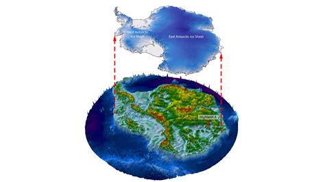
The Gamburtsev Mountains, located near the center of the East Antarctic Ice Sheet, are completely buried under thousands of meters of ice. Because of this, direct observation of the mountains’ surface is impossible. Instead, scientists rely on remote sensing techniques, primarily ice-penetrating radar, to image the landscape beneath the ice.
The radar data, collected over several years by aircraft flying over the region, bounces radio waves off the ice and the bedrock below. By analyzing the reflected signals, scientists can create detailed maps of the topography hidden beneath the ice.
The new study focused on a specific region of the Gamburtsev Mountains known as the Aurora Subglacial Basin. The analysis of this radar data revealed a network of deeply incised river valleys and lake basins, remarkably well-preserved despite being buried under ice for millions of years.
“The really exciting thing is that these ancient river valleys and lakes are so well-preserved,” said Jamieson. “They haven’t been completely eroded away by the ice sheet, which suggests that the ice sheet has been relatively stable in this area for a very long time.”
A Pre-Glacial Landscape
The discovery of these ancient landforms suggests that the Gamburtsev Mountains were not always covered in ice. Before the onset of major glaciation in Antarctica, around 34 million years ago, the mountains were likely a temperate landscape, with flowing rivers and lakes.
“We think that this area was once a much warmer, wetter environment,” said Neil Ross, a professor of polar geophysics at Newcastle University, another of the study’s lead authors. “Rivers would have flowed through these valleys, and there would have been lakes in the basins.”
The presence of these pre-glacial landforms challenges the traditional view that the Gamburtsev Mountains were primarily shaped by glacial erosion. While glaciers certainly played a role in sculpting the landscape, the underlying topography was already in place before the ice sheet formed.
“The ice sheet hasn’t just bulldozed everything away,” said Jamieson. “It’s actually preserved a lot of the pre-glacial landscape.”
Implications for Ice Sheet Stability
The discovery of this ancient landscape has important implications for understanding the stability of the East Antarctic Ice Sheet. The fact that these landforms have been preserved for millions of years suggests that the ice sheet in this region has been relatively stable over long periods.
“This tells us that the ice sheet is not as dynamic as we might have thought,” said Ross. “It’s been sitting there, in roughly the same place, for millions of years.”
However, the study also highlights the potential vulnerability of the ice sheet to future climate change. The ancient river valleys and lake basins could act as pathways for meltwater to flow beneath the ice sheet, potentially accelerating its disintegration.
“These valleys could act as conduits for meltwater to get to the base of the ice sheet,” said Jamieson. “If that happens, it could destabilize the ice sheet and cause it to melt more quickly.”
Future Research
The study raises many questions about the history and evolution of the East Antarctic Ice Sheet. Future research will focus on further characterizing the ancient landscape beneath the ice and understanding how it has influenced the behavior of the ice sheet over time.
“We need to get a better understanding of the geology of this region,” said Ross. “We need to know what kind of rocks are there, and how they’ve been weathered and eroded.”
Scientists also plan to use computer models to simulate the behavior of the ice sheet under different climate scenarios. These models will help to predict how the ice sheet might respond to future warming and how meltwater might flow through the ancient river valleys.
“We need to understand how these valleys might affect the stability of the ice sheet in the future,” said Jamieson. “This is a really important question for understanding the future of Antarctica.”
The research team hopes that their findings will help to inform policymakers and the public about the importance of protecting the Antarctic environment. The East Antarctic Ice Sheet is a vital component of the global climate system, and its stability is crucial for the future of the planet.
Deeper Dive into the Discovery
The significance of this discovery goes beyond simply identifying an old landscape. It reframes our understanding of the glacial processes in East Antarctica and offers a critical baseline for predicting future ice sheet behavior. The well-preserved nature of the subglacial landscape is particularly striking because glacial erosion is typically a powerful force, capable of significantly altering or obliterating pre-existing features. The survival of these ancient river valleys and lakes suggests that the ice sheet in this area hasn’t been as actively eroding as previously believed, implying a degree of stability over millions of years.
To fully appreciate the implications, it’s essential to understand the geological context. The Gamburtsev Mountains are thought to have formed through a process called rifting, similar to the formation of East Africa’s rift valleys. This process created a rugged mountain range, which then became the foundation for the East Antarctic Ice Sheet. The pre-glacial landscape that the scientists discovered represents the surface of these mountains before the ice sheet covered them. This surface would have been sculpted by rivers, lakes, and weathering, creating a diverse topography that now lies hidden beneath the ice.
The radar technology used in this research is a crucial tool for studying subglacial environments. The ice-penetrating radar emits radio waves that can travel through the ice and reflect off the bedrock below. By analyzing the travel time and strength of these reflections, scientists can create detailed images of the subglacial topography. The data collected in this study is particularly valuable because it covers a large area and provides high-resolution images of the ancient landscape. This detailed mapping allows scientists to identify subtle features, such as small river valleys and lake basins, that would be difficult to detect with less precise methods.
The implications of this discovery for ice sheet stability are significant. The ancient river valleys and lakes could act as pathways for meltwater to flow beneath the ice sheet, potentially accelerating its disintegration. This process, known as basal lubrication, can reduce friction between the ice and the bedrock, allowing the ice to slide more easily towards the ocean. If this happens on a large scale, it could lead to a significant increase in sea level.
However, the study also suggests that the East Antarctic Ice Sheet may be more resilient than previously thought. The fact that the ancient landscape has been preserved for millions of years indicates that the ice sheet has been relatively stable in this area for a long time. This stability may be due to the topography of the Gamburtsev Mountains, which could act as a barrier to ice flow. It could also be due to the cold temperatures in the region, which may have prevented significant melting at the base of the ice sheet.
Future research will focus on further characterizing the ancient landscape beneath the ice and understanding how it has influenced the behavior of the ice sheet over time. Scientists plan to collect more radar data to create even more detailed maps of the subglacial topography. They also plan to drill through the ice sheet to collect samples of the bedrock and the sediments in the ancient lake basins. These samples will provide valuable information about the geology of the region and the history of the ice sheet. Computer models will also be used to simulate the behavior of the ice sheet under different climate scenarios. These models will help to predict how the ice sheet might respond to future warming and how meltwater might flow through the ancient river valleys.
Connecting the Dots: Global Climate Implications
The East Antarctic Ice Sheet holds a massive amount of frozen water. If it were to melt completely, global sea levels would rise by approximately 60 meters (nearly 200 feet). Even a partial melting of the ice sheet could have devastating consequences for coastal communities around the world. Therefore, understanding the stability of the East Antarctic Ice Sheet is crucial for predicting future sea level rise and mitigating the impacts of climate change.
The discovery of the ancient landscape beneath the ice adds a new layer of complexity to this understanding. The presence of these pre-glacial landforms suggests that the ice sheet has been influenced by factors that were not previously considered. The river valleys and lakes could act as pathways for meltwater, potentially accelerating ice sheet disintegration. On the other hand, the topography of the Gamburtsev Mountains could provide stability to the ice sheet, preventing it from flowing too quickly towards the ocean.
The key to unlocking the future of the East Antarctic Ice Sheet lies in understanding the interplay between these different factors. By combining radar data, geological samples, and computer models, scientists are gradually piecing together a more complete picture of the ice sheet’s history and its potential future.
This research also highlights the importance of international collaboration in polar science. The data used in this study was collected by researchers from multiple countries, working together to understand one of the most important and challenging scientific problems facing humanity. Continued collaboration and data sharing will be essential for making progress in this field.
The Broader Context: Antarctica’s Role in Climate Change
Antarctica plays a critical role in regulating the Earth’s climate. The continent’s vast ice sheets reflect sunlight back into space, helping to keep the planet cool. The Southern Ocean, which surrounds Antarctica, absorbs a significant amount of carbon dioxide from the atmosphere, helping to mitigate the effects of greenhouse gas emissions. Changes in Antarctica’s ice sheets and ocean currents can have a profound impact on global climate patterns.
The West Antarctic Ice Sheet is already showing signs of instability. Several glaciers in West Antarctica are melting at an accelerating rate, contributing to sea level rise. The East Antarctic Ice Sheet, which is much larger and colder than the West Antarctic Ice Sheet, has been considered more stable. However, recent studies have suggested that even the East Antarctic Ice Sheet may be vulnerable to climate change.
The discovery of the ancient landscape beneath the Gamburtsev Mountains underscores the need for continued research and monitoring of Antarctica. The continent is a complex and dynamic environment, and there is still much that we don’t understand about its role in the global climate system. By investing in polar science, we can gain a better understanding of the challenges facing Antarctica and develop strategies to protect this vital region.
Technological Advancement in Antarctic Research
The progress in Antarctic research has been greatly aided by advancements in technology. Ice-penetrating radar is just one example. Other technologies, like satellite imagery, GPS tracking, and autonomous underwater vehicles (AUVs), have also played a crucial role in expanding our knowledge of the continent.
Satellite imagery allows scientists to monitor changes in ice sheet thickness, ice flow velocity, and sea ice extent. GPS tracking is used to measure the movement of glaciers and ice shelves. AUVs can explore the ocean beneath ice shelves, collecting data on water temperature, salinity, and ice thickness.
These technologies are constantly evolving, enabling scientists to conduct more sophisticated and detailed research in Antarctica. As technology continues to improve, we can expect even more exciting discoveries in the years to come.
The Ethical Dimensions of Antarctic Exploration
As we continue to explore and study Antarctica, it’s important to consider the ethical dimensions of our activities. Antarctica is a unique and fragile environment, and we have a responsibility to protect it. The Antarctic Treaty System, which governs activities on the continent, emphasizes the importance of environmental protection and peaceful scientific research.
The treaty prohibits military activities, mineral exploitation, and nuclear explosions in Antarctica. It also requires that all activities be conducted in a manner that minimizes their impact on the environment. As we continue to learn more about Antarctica, it’s crucial that we adhere to the principles of the Antarctic Treaty System and ensure that our activities are sustainable and responsible.
The Future of Antarctic Research
The future of Antarctic research is bright. Scientists are developing new technologies and approaches to study the continent, and international collaboration is stronger than ever. As we continue to unravel the mysteries of Antarctica, we will gain a deeper understanding of the Earth’s climate system and the challenges facing our planet.
The discovery of the ancient landscape beneath the Gamburtsev Mountains is just one example of the exciting discoveries that are being made in Antarctica. As we continue to explore this remote and fascinating continent, we can expect many more surprises in the years to come. These discoveries will not only advance our scientific knowledge but also help us to protect this vital region for future generations.
FAQ Section
1. What exactly was discovered in the Gamburtsev Mountains?
Scientists discovered a remarkably well-preserved ancient landscape hidden beneath the East Antarctic Ice Sheet in the Gamburtsev Mountains. This landscape includes a network of river valleys and lakes that existed before the current ice sheet formed, dating back at least 34 million years. “What we found is that this landscape looks surprisingly similar to landscapes in Canada or Scandinavia before they were covered by ice sheets,” said Professor Stewart Jamieson.
2. How did scientists discover this hidden landscape?
Due to the thickness of the ice, direct observation is impossible. Scientists used ice-penetrating radar technology. Aircraft equipped with radar instruments flew over the area, emitting radio waves that bounced off the ice and the bedrock below. By analyzing the reflected signals, researchers created detailed maps of the topography hidden beneath the ice.
3. Why is this discovery significant?
This discovery challenges the conventional view that the Gamburtsev Mountains were solely sculpted by glacial erosion. It suggests that a pre-existing landscape was preserved under the ice, indicating a degree of stability in the ice sheet over millions of years. This also provides insights into the potential vulnerability of the ice sheet to climate change, as the ancient river valleys could serve as pathways for meltwater. “This tells us that the ice sheet is not as dynamic as we might have thought,” said Professor Neil Ross. “It’s been sitting there, in roughly the same place, for millions of years.”
4. What are the potential implications for the stability of the East Antarctic Ice Sheet?
The presence of these ancient river valleys and lake basins could act as conduits for meltwater to flow beneath the ice sheet. This basal lubrication could reduce friction between the ice and the bedrock, potentially accelerating the ice sheet’s disintegration and contributing to sea level rise. Conversely, the preservation of the landscape also suggests that the ice sheet has been relatively stable in this region for a very long time.
5. What are the next steps in this research?
Future research will focus on further characterizing the ancient landscape, collecting geological samples, and using computer models to simulate the behavior of the ice sheet under different climate scenarios. Scientists aim to understand how this subglacial landscape has influenced the ice sheet’s behavior over time and how it might affect its stability in the future. “We need to understand how these valleys might affect the stability of the ice sheet in the future,” said Jamieson. “This is a really important question for understanding the future of Antarctica.”